In an extreme flooding event across eight districts in Bangladesh, roughly three million people have been left stranded.
According to Bangladeshi newspaper The Daily Star, locals reported not having seen such severe flooding in 37 years.
“I haven’t seen so much water in the last 20 years. Everything in my house is wrecked because the water has risen to waist level,” said Mohammad Masum, Feni district resident, as Reuters reported.
Feni was among the districts most affected by the flooding, along with Moulvibazar, Chittagong, Habiganj, and Comilla. According to the Flood Forecasting and Warning Centre (FFWC), five major rivers in the area were above danger levels.
“The local administration is working in coordination with the deputy commissioners of the flood-affected districts, the coordinators of the Anti-Discrimination Student Movement, the army, and volunteers,” said KM Ali Reza, a secretary with the Ministry of Disaster Management and Relief, who expressed concern that there would be more flooding in the coming few days, as reported by The Daily Star.
Reza said food and relief materials had been sent to the affected districts.
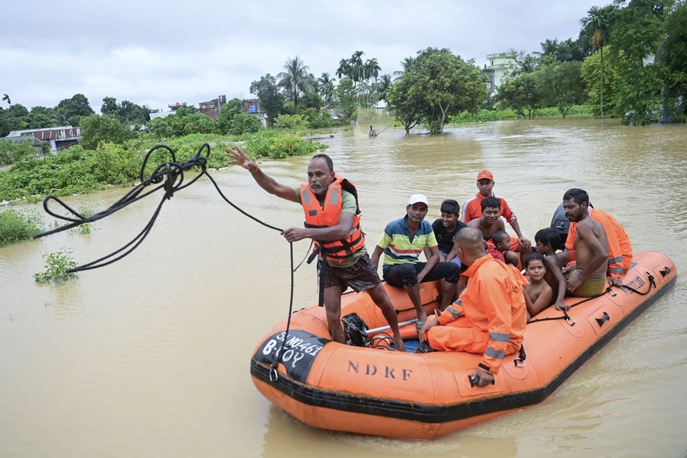
Musammat Shahina Akter, a Feni senior official, said high schools and government buildings had become makeshift shelters, with more than 25,000 taking shelter in relief camps, CNN reported.
“We don’t expect people to be able to return home anytime soon,” Akter said, adding that the rain was slowing down, but that water levels could not recede until the rainfall stopped, as reported by CNN.
Heavy monsoon rainfall led to residents evacuating their flooded homes by boat. The FFWC warned that continued rains meant water levels could keep rising in the next 24 hours, Reuters reported.
Roads were washed out or submerged in several regions, interfering with relief efforts in isolated communities, officials said.
“Flooding is common in the Indian Peninsula because of the monsoon rains. The monsoon winds enter the Indian Peninsula by July and continue till October,” Subhadip Majumdar, a writer in Delhi, India, told EcoWatch. “Bangladesh is a land of great rivers, like the Padma, Arial Khan, and Meghna, and that is why the country is ravaged each year by floods. India and Bangladesh are very fertile lands because of such rainfall. In the North, the river Brahmaputra is a braided river with heavy sediment deposits that also cause floods. Often the dams on those rivers are kept open during the monsoon, which causes tremendous flooding in Assam, Bengal, and Bangladesh.”
A 2015 World Bank Institute analysis estimated that in Bangladesh 3.5 million people were at risk of flooding each year, reported Reuters. Scientists have attributed the intensification of catastrophic events like flooding to climate change.
“We would like to point out that the catchment areas of Gumti River that flows through India and Bangladesh have witnessed the heaviest rains of this year over the last few days,” India’s foreign ministry said, as Reuters reported. “The flood in Bangladesh is primarily due to waters from these large catchments downstream of the dam.”
Twelve people died in the state of Tripura, India, due to floods and landslides, disaster management official Suman Deb told Reuters.
Amit Shah, India’s interior minister, said on social media that the country’s government had sent disaster management teams to Tripura to assist with rescue and relief operations.
Multiple residents living near Cumilla’s Gomati River told CNN that India was to blame for the flood. A large portion of Bangladesh is comprised of Himalayan river deltas from the Brahmaputra and Ganges, which begin in India and flow through Bangladesh to the sea.
“This flood came from India because India opened the dam. If this water goes over, it will flood the whole area and Comilla city,” said Shariful Islam, a resident of the area for the past 25 years, as reported by CNN.
The Ministry of External Affairs in India dismissed accusations that the flooding had been caused by the opening of a Gomati River dam. The river flows through Tripura, entering Bangladesh by way of Comilla. The ministry said the flooding was caused by the “heaviest rains of this year over the last few days.”
“We have seen concerns being expressed in Bangladesh that the current situation of flood in districts on the eastern borders of Bangladesh has been caused by the opening of the Dumbur dam upstream of the Gumti River in Tripura. This is factually not correct,” the ministry said in a statement.
The statement said Tripura state was experiencing a power outage, which it said had brought about “problems of communications,” but did not provide further details.
“Floods on the common rivers between India and Bangladesh are a shared problem inflicting sufferings to people on both sides and requires close mutual cooperation towards resolving them,” said India’s foreign ministry, as Reuters reported.
This article was reposted from EcoWatch.
We hope you appreciated this article. At People’s World, we believe news and information should be free and accessible to all, but we need your help. Our journalism is free of corporate influence and paywalls because we are totally reader-supported. Only you, our readers and supporters, make this possible. If you enjoy reading People’s World and the stories we bring you, please support our work by donating or becoming a monthly sustainer today. Thank you!
CONTRIBUTOR