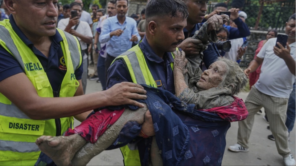
KATHMANDU, Nepal—At least 389 people are dead and 1,400 missing in the still developing flash flood disaster at the Nepal-China border, with casualty numbers only expected to rise. Shortly after 8:30 a.m. on Aug. 26, a wall of water, ice, and rock came barreling down the Bhote Koshi gorge on Nepal’s northern frontier with Tibet.
It is the second time in 14 months that a flood poured down this same gorge and erased the same bridge, the same highway, and the same border town. Nepali officials, environmental researchers, and residents of the valley increasingly describe what keeps happening here not as bad luck, or an unpredictable act of nature, but as the result of a landscape built directly into the path of a hazard that has now struck twice in just over a year.
Its origin was roughly 35 kilometers upstream, high in the Lhende Khola catchment. A large mass of ice and rock detached from a slope and fell into the river, damming it. Water built up behind the debris until the dam failed, and the accumulated volume was released downstream all at once.
A magnitude 4.4 earthquake was recorded on the Tibetan side of the border at about the same time; whether it triggered the collapse has not been established, and Nepali scientists have been careful to say so. Even the location of the collapse is disputed: Preliminary satellite analysis places it on the Nepali side of the border, while other analysts put it well inside Tibet.

In the hour that followed, the surge destroyed the Rasuwagadhi border checkpoint and the Sino-Nepal Friendship Bridge, also known as Miteri Bridge, Nepal’s crossing into China. It swept through Timure, a border trading village, and tore apart the site of a dry port that had been under construction there for years. It hit Syabrubesi, the market town where the road ends and the walking trail into the Langtang Valley begins.
It carried away roughly 42 kilometers of the Pasang Lhamu Highway, Nepal’s only overland link to Tibet, and damaged an estimated 700 megawatts of hydropower capacity along the Bhote Koshi and Trishuli Rivers.
As of press time, the Nepal Tourism Board said many of the hundreds unaccounted for are tourists, the large majority of them foreign nationals: Indian pilgrims returning from Mount Kailash, trekkers bound for Langtang, and cross-border traders. Both figures were provisional and kept climbing into Thursday as rescue teams reached areas further downstream.
The police log captures the brutality of the flood’s reach. Of the 95 bodies recovered on the first day, only one was found in Rasuwa district, where the flood originated. The rest were pulled from the river more than 200 kilometers downstream.
A flood Nepal has seen before
Over a year ago, on July 8, 2025, supraglacial lakes sitting on the Purepu Glacier in Tibet, at an elevation of about 5,150 meters, drained suddenly. Satellite imagery had shown the lake system growing to roughly 638,000 square meters before it emptied.
That flood destroyed the Sino-Nepal Friendship Bridge at Rasuwagadhi, damaged seven hydropower projects representing around 8% of Nepal’s electricity generating capacity, and killed at least 28 people. It also wrecked about 60% of the Timure dry port—a Chinese-funded facility budgeted at 2.8 billion rupees ($18.3 million USD) that was 8% complete and scheduled to open in early 2026—smashing its warehouses, parking areas, and riverbank retaining walls. A customs worker at the site said afterward that it had “reverted to the state it was in ten years ago.”
Nepal’s Department of Hydrology and Meteorology did not detect the 2025 flood until the water reached Betrawati, some 60 kilometers downstream of where it had entered the country from China. In the 14 months between that flood and this one, the detection gap never closed. Nepal still has no mechanism for receiving real-time hydrological data from the Chinese side of the border. When a surge enters the Bhote Koshi, the time available to warn anyone downstream is measured in minutes.
The Friendship Bridge had since been rebuilt and reopened under a new name, the Miteri Bridge, miteri meaning “friendship” in Nepali, and the dry port was still under repair. Both were destroyed again on Wednesday.
Rescue response
Rescue began within hours and has been constrained throughout by the fact that the flood destroyed the road to the disaster itself.
The Nepali Army, Nepal Police, and Armed Police Force were deployed immediately, with army helicopters carrying medical teams and private aircraft placed on standby. Air access largely remains, for the moment, the only method of reaching the area.
Prime Minister Balendra Shah convened the National Disaster Risk Reduction and Management Authority and subsequently the national council. The cabinet declared the affected municipalities in Rasuwa, Nuwakot, and Dhading crisis-hit zones for three months, unlocking emergency procurement and outside assistance.
It ordered free medical treatment for the injured through government hospitals and army facilities, compensation for bereaved families under existing law, food and shelter for the displaced, and the restoration of roads, power, drinking water, and telecommunications. Residents of low-lying areas downstream were ordered to move to higher ground.
A landscape reorganized around risk
Researchers who study the region’s development do not read what happened here as an accident, or simply a failure to anticipate risk. Geographers Galen Murton and Austin Lord, who have spent years studying the political economy of Himalayan infrastructure, describe it instead as the predictable consequence of a development model that prioritizes economic growth and the interests of outside investors over the people living in the danger zone.
Those people, they and other researchers argue, often have the least influence over the infrastructure and development decisions that shape their own exposure to disaster—decisions increasingly driven by wealthier states and international capital.

That was not always the relationship between people and the river here. Traditional Tamang settlements in the valley were built around flood mitigation: Agricultural land and rice fields were often located close to the river, where proximity to water made them productive, while permanent houses were built higher up the valley slopes, away from the most exposed ground. Flooding was not treated as an exceptional event to be eliminated, but as a recurring condition that settlement and agricultural practice were organized around.
Over the past 70 years, though, development has fundamentally altered that relationship.
Roads, outmigration, and the shift from agricultural livelihoods toward wage-based economies have reorganized where people live and work. Roads are frequently built along floodplains because those routes are easier and cheaper to construct; houses and businesses then follow the road, concentrating settlement precisely in the areas most exposed to flooding.
What has emerged, researchers and local officials say, is not simply an increase in physical exposure, but a transformation in the social and economic conditions that produce vulnerability in the first place.
By one global measure, Nepal is responsible for approximately 0.05% of current global carbon dioxide emissions, and 0.01% of cumulative emissions since 1751; the average Nepali emits 0.63 tons of CO2 a year. This is a country that has contributed almost nothing to the warming now dismantling its own water towers, and that is losing bridges, power stations, trade revenue, roads, and people to that warming faster than it can rebuild them.

Timure was a village of about 500 people a decade ago. The road, the customs post, and the dry port turned it into a boomtown; people returned from labor migration abroad because there was, for the first time in years, work to be had at home. That is what was standing in the water on Wednesday morning.
Precarity is not a metaphor here. It is the condition of building a livelihood in a narrow valley whose upstream hazard is changing faster than anyone is measuring it, across a border from a neighbor that has not been sharing its data, funded by savings that cannot be recovered, in a country that did not cause the problem it is now living through.
It is also not the whole story. Nepal’s future is precarious under climate change, but its people are not defined only by that precarity: Timure’s return migrants built a boomtown here once already. Whether they get the chance, and the resources, to do it again is now, once more, an open question.
We hope you appreciated this article. At People’s World, we believe news and information should be free and accessible to all, but we need your help. Our journalism is free of corporate influence and paywalls because we are totally reader-supported. Only you, our readers and supporters, make this possible. If you enjoy reading People’s World and the stories we bring you, please support our work by donating or becoming a monthly sustainer today. Thank you!
CONTRIBUTOR