Tropical Storm Debby gained strength over the weekend to become a Category 1 hurricane, making landfall on Florida’s Gulf Coast early Monday morning with maximum sustained winds of 75 miles per hour, reported The Associated Press.
The National Hurricane Center issued a storm surge warning for the coasts of Florida, Georgia and South Carolina. More than 283,000 Florida customers were without power, according to Poweroutage.us.
“This is going to be an event that is going to be probably here for the next five to seven days, maybe as long as 10 days, depending on how much rainfall we get,” said Kevin Guthrie, executive director of the Florida Division of Emergency Management, as Reuters reported.
Guthrie said the storm had already dumped as much as a foot of rain in some areas of southwest Florida.
The hurricane center forecast “catastrophic flooding,” saying Debby would move back offshore by Tuesday night, then gain strength before coming inland for a second time to drench Georgia and the Carolinas.
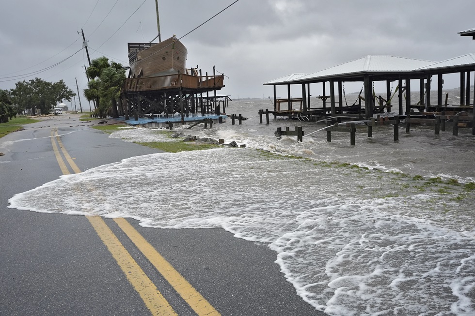
Debby made landfall on the Big Bend coast near Steinhatchee, one of the state’s least populated areas, reported The Associated Press.
Less than a year earlier, Hurricane Idalia made landfall about 20 miles away, a Category 4 storm with winds of up to 125 mph that brought devastation to the region.
“Two in less than a year is pretty bad,” said Chris Williams, a marina operator who lost power when Debby came ashore around 5:30 Monday morning, as The Associated Press reported. “You do everything you can possibly do to prepare. And when you’ve done that, clean up and put it back together and move forward.”
Forecasters predicted a storm surge of six to 10 feet in areas near Big Bend, which hurricane specialist John Cangialosi said was “a very vulnerable spot.”
The counties of Manatee and Sarasota had already seen 10 to 12 inches of rain.
The National Weather Service in Georgia was predicting major river flooding, with water levels potentially more than doubling later this week.
The driver of an 18-wheeler was killed Monday morning when his truck crashed into the Tampa Bypass Canal.
The National Hurricane Center said Debby was moving toward the north-northwest with maximum sustained winds of 70 mph.
“A gradual decrease in forward speed with a turn toward the east is expected later today and Tuesday. On the forecast track, the center will move across southeastern Georgia tonight and Tuesday, and move offshore of the South Carolina coast by late Tuesday and Wednesday,” the hurricane center said. “The combination of storm surge and tide will cause normally dry areas near the coast to be flooded by rising waters moving inland from the shoreline.”
The center said the storm was predicted to bring from six to 18 inches of rainfall through Wednesday morning across northern Florida to central and northeast North Carolina.
“This rainfall will likely result in areas of considerable flash and urban flooding, with significant river flooding expected,” the hurricane center said.
This article was reposted from EcoWatch.
We hope you appreciated this article. At People’s World, we believe news and information should be free and accessible to all, but we need your help. Our journalism is free of corporate influence and paywalls because we are totally reader-supported. Only you, our readers and supporters, make this possible. If you enjoy reading People’s World and the stories we bring you, please support our work by donating or becoming a monthly sustainer today. Thank you!
CONTRIBUTOR