To many Americans, California is defined by its ranging coastline and the sandy beaches and multi-million dollar homes that line its 840-mile stretch. As sea levels continue to rise, it’s no secret then, that the state and its inhabitants are facing a crisis. Hollywood knows this, too, as movie after movie over the last decade has depicted the state’s biggest monuments being taken by the sea.
Lucas Zucker and Amee Raval have bigger fears, however, than the Santa Monica Pier being eaten by the ocean. “People tend to only think about certain destinations, your Malibus and Santa Barbaras — places where celebrities live — these loom large in the public imagination and they shape how policymakers think about sea-level rise,” Zucker, a policy director at Central Coast Alliance United for a Sustainable Economy, or CAUSE, told Grist.
But, Zucker says, if you actually took the 840 mile trip along the coast, you’d see a different reality. “You would see huge swaths of the coast that have been primarily used for heavy industry, commercial shipping, and toxic military bases,” he explained. And those swaths would be home to majority Black and Latino communities, who are no strangers to the effects of pollution and toxic chemicals.
These two environmental justice activists, whose communities are nearly 400 miles apart, represent a group of California residents in predominantly Black and Latino communities that are five times more likely than the general population to live within half a mile of a toxic site that could flood by 2050, according to a new statewide mapping project led by environmental health professors at UC Berkeley and UCLA (including Grist board member Rachel Morello-Frosch). The study outlines more than 400 hazardous facilities that will face major flooding events by the end of the century, exposing residents to elevated levels of toxic water and dangerous chemicals.
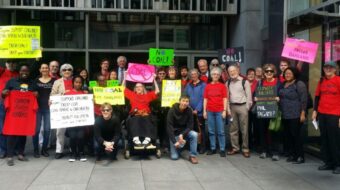
The Toxic Tides project is a first-of-its-kind look at the consequences of sea-level rise on California’s historically neglected environmental justice communities in hopes of urging more federal and state officials to address the expected crisis and transition away from the use of these toxic facilities. “It adds to the urgency,” Raval, policy director at the Asian Pacific Environmental Network, or APEN, told Grist. “We’re equipped and supported now with the data and the research to legitimize our community concern and our vision for a just transition.”
CAUSE, based in Ventura County, and APEN, based in Richmond and Oakland, along with three other environmental justice groups and academic researchers, spent three years combing through federal toxic landmark databases in addition to interviewing community members throughout the entire state to produce the new maps. In all, the coalition created a series of searchable maps and databases to weave together California’s flooding hotspots, which industrial facilities face particular risk, and how lower-income communities of color would be disproportionately impacted. The hotspots they found were unsurprising, Raval told Grist, but nonetheless damning.
“We know who the polluters are. The same big polluters that are destabilizing our climate and driving sea-level rise,” Raval said. “When these toxic facilities flood, they will release even more toxins into our air, water, and land.”
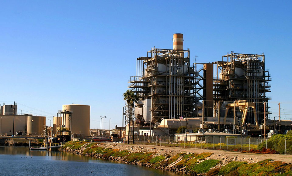
The project outlined three major hotspots: Wilmington, Richmond, and Oxnard, California. In Wilmington, a pocket of South Los Angeles dubbed an “island in a sea of petroleum,” at least 20 industrial facilities, landfills, oil terminals, and incinerators are expected to regularly flood this century. In Oxnard, there are at least nine hazardous sites prone to flooding. Up the coast in Richmond, there are more than a dozen toxic sites at risk, including the Chevron oil refinery, which produces more than 10 million gallons of oil every day, making it the 27th biggest refinery in the country.
Because of the immediate impact to be felt by affected community members, advocates like Zucker and Raval knew how important it was to not just present this data to policymakers, but to the people who live there. This was particularly important in the three areas spotlighted by the project, all of which are home to thousands of non-English speakers. As an environmental justice organizer, Raval says, it’s vitally important to meet people where they are and to meet their specific needs. The group spent months explaining their findings to residents up and down the state in an effort to combine their research “with making those authentic partnerships with community members and advocates who live this reality every day.”
Beyond educating and organizing their communities, the Toxic Tides coalition is actively working to secure funds to help clean up and transition away from these toxic sites, while not reinforcing existing social inequalities and environmental injustices. The groups are advocating for funds set aside in the newly passed Bipartisan Infrastructure Law’s Superfund cleanup provisions to be used on many of the sites outlined in the project. On a state level, the coalition is hoping to leverage California’s recent $30 billion budget surplus to be used on these frontline environmental justice communities.
“We can’t be dismissed or not taken seriously anymore,” Zucker said. “Our communities already knew of all this was going on in our backyards, but now we have the numbers and the data visualizations to back it up to scholars, planners, and elected officials.”
This article was reposted from Grist.org.
CONTRIBUTOR