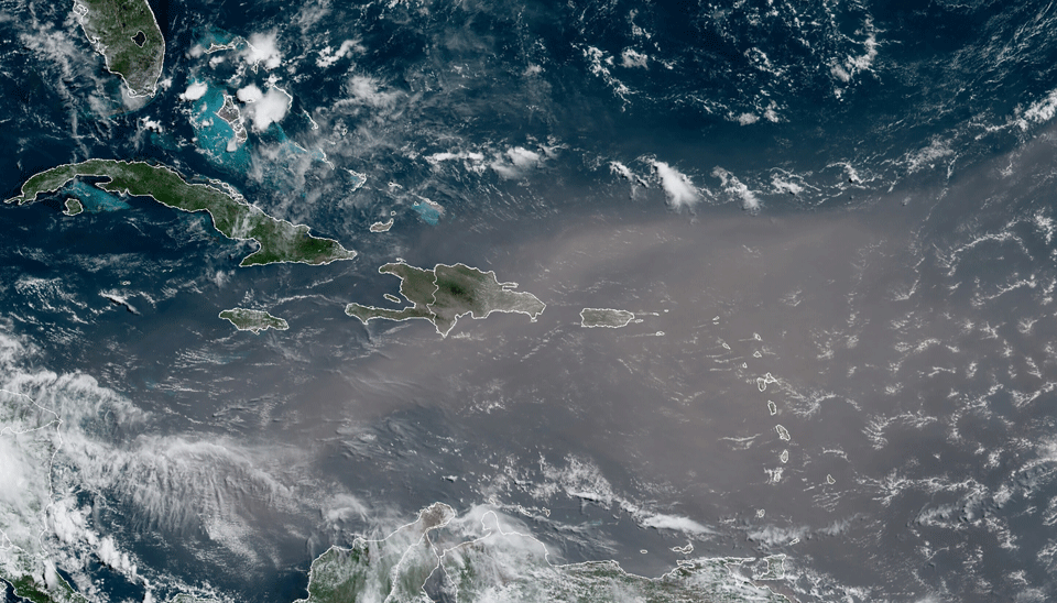
This satellite photo provided by the National Oceanic and Atmospheric Administration, NOAA, shows a cloud of dust coming from the Sahara desert arriving to the Caribbean Monday, June 22, 2020. The massive cloud of dust is blanketing the Caribbean as it heads to the U.S. with a size and concentration level that meteorologists say hasn't been seen in roughly half a century. (NOAA via AP)
A massive cloud of dust from the Sahara Desert is expected to reach the Southeastern U.S. by Wednesday.
While the weather pattern driving the cloud is not unusual, the amount of dust is, according to KSLNewsRadio. National Aeronautics and Space Administration (NASA) Colonel Doug Hurley snapped a photo from on board the International Space Station, as NDTV reported.
“We flew over this Saharan dust plume today in the west central Atlantic,” he tweeted Sunday. “Amazing how large an area it covers!”
The dust is part of something called the Saharan Air Layer (SAL), a mass of dry, dusty air that travels over the North Atlantic every three to five days between mid-June and mid-August, according to National Oceanic and Atmospheric information reported by KSL.
“Every so often, when the dust plume is large enough and trade winds set up just right, the dust can travel thousands of miles across the Atlantic and into the U.S.,” CNN Meteorologist Haley Brink said.
The current plume emerged off of North Africa last weekend and has already traveled more than 3,000 miles to reach the eastern Caribbean Sea, The Weather Channel reported.
It covers an area larger than the lower 48 states and Western Europe.
The dust is expected to travel more than 5,000 miles to reach the U.S., according to CNN. But its effects for the country will mostly be positive: brilliant sunsets and suppressed hurricane activity.
The sunsets are because the tiny dust particles tens of thousands of feet in the air filter the sun’s rays at the beginning and end of the day. They also cause a blue sky at midday to have a milky sheen.
The hurricane suppression is because tropical storms don’t do well with dry air.
“The SAL can have a significant negative impact on tropical cyclone intensity and formation,” Jason Dunion explained for NOAA. “Its dry air can act to weaken a tropical cyclone by promoting downdrafts around the storm, while its strong winds can substantially increase the vertical wind shear in and around the storm environment. It is not yet clear what effect the SAL’s dust has on tropical cyclone intensity, though some recent studies have suggested that it can actually impact the formation of clouds.”
However, the cloud could worsen air quality in some places, which could make symptoms worse for people suffering from respiratory conditions like asthma, The Weather Channel pointed out.
This article was reposted from EcoWatch.


