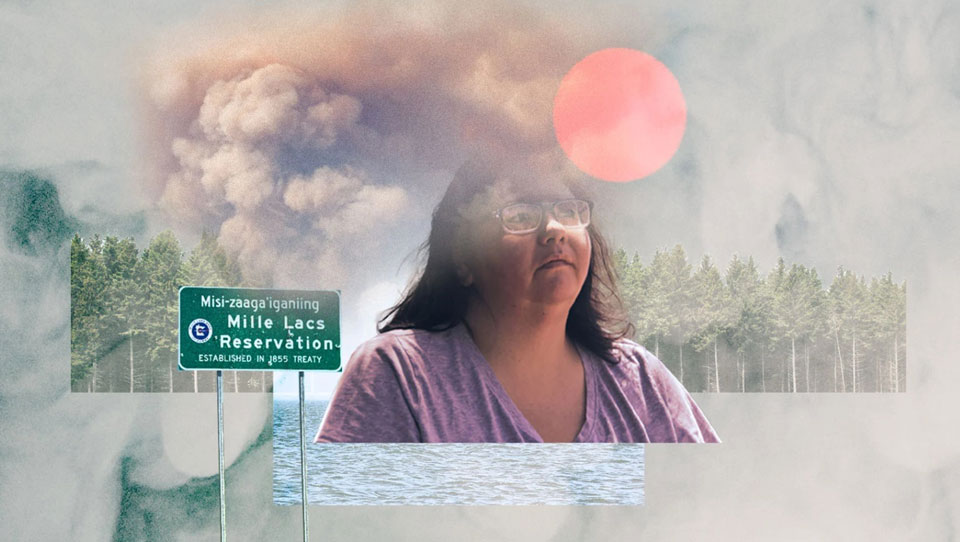
On July 29, 2021, Li Boyd woke up to the smell of smoke. It was her birthday — she was turning 38 — and she had rented a boat to take her parents and aunts out on the lake near her home in central Minnesota, about 90 minutes north of the Twin Cities. But that morning, when she looked outside her window and found a thick, yellow-gray haze, she figured it was best to avoid going outside. Her older family members all had respiratory issues, and as the day went on and the smoke grew thicker, she worried about how it would affect them. They celebrated in her house, sealing the windows as tightly as they could.
Boyd is a member of the federally recognized Mille Lacs Band of Ojibwe. That day, her government sent out alerts through Facebook, email, and text message, warning citizens to stay indoors and close their windows. Youth programs were canceled, and public employees were told to go home. The smoke was “so intense,” Boyd said, that her aunt called the police in a panic to report that something was on fire.
It was Canada, they told her; wildfires burning in nearby Alberta had sent a column of smoke south into Minnesota, where it reached Mille Lacs and settled on the reservation like a blanket. Air quality in the United States is measured on a point scale called the air quality index, or AQI, where a score under 50 is considered “good” while one over 150 is “unhealthy.” That day, a private sensor on the Mille Lacs Reservation registered an AQI-equivalent reading of 667.2 — the highest ever recorded in the state of Minnesota.
Smoke had drifted over the reservation before, but that day was a wake-up call. “I didn’t need the news to tell me that that was a record event or that it was extraordinary,” Boyd recalled nearly a year later, sitting in a lawn chair in her front yard on a clear day in May. “We could tell because literally anybody you talked to was like, ‘What is happening?’”
That summer, as fires burned pest- and drought-stricken forests to the north and west, air pollution levels on the Mille Lacs Reservation were above normal nearly every day in July and August. The state issued 29 air quality alerts, triggered by an AQI of over 100, for the Mille Lacs area; in previous years, the tribe could expect to see around four. For Boyd, it became clear that climate change was here — and that it would affect the tribe in ways it hadn’t anticipated.
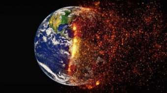
Across the country, wildfires are becoming more frequent and intense as climate change dries out forests. Scientists and public health advocates are also increasingly recognizing the danger posed not just by the flames themselves, but the smoke that they generate. Smoke from megafires in the West has blocked out the sun as far as Washington, D.C.; asthma cases and deaths from wildfire smoke now affect more people in the Eastern U.S. than in the West.
But these impacts are not distributed equally. Communities of color and low-income residents in urban areas already shoulder disproportionate air pollution burdens from sources like truck traffic and industrial waste sites. But Indigenous communities, which tend to be located in rural areas closest to blazes and often have difficulties accessing air filters and upgrading homes to keep out the smallest particles, can be more vulnerable to the impacts of intensifying pollution from wildfires than other groups.

Last year, researchers at the University of California examined the impact of wildfires on communities around the state over the past 20 years. Their study found that areas with a higher percentage of Indigenous residents experienced more frequent and severe fires. In the most highly affected areas, the Indigenous population was about three times higher than the average census tract. Even the topography of reservations like Mille Lacs can concentrate dangerous levels of wildfire haze, threatening tribes’ rights to hunt, fish, and use their land guaranteed under treaties with the U.S. government.
A Columbia University study published in March found that air pollution in Native American communities is worse than in non-Native areas, despite nationwide improvements in air quality over the last 20 years. These health disparities aren’t just from exposure to wildfire smoke, but experts say it is a significant factor. In 2018, one study found that American Indian and Alaska Native people were 20 percent more likely to have asthma compared to non-Hispanic whites.
Tribes are now calling out a lack of federal funding for programs to monitor air pollution, as well as for upgrading homes and infrastructure to deal with the worsening smoke. Money supplied by the Environmental Protection Agency’s air grants program has remained stagnant for the last 20 years, even as more Indigenous nations have begun applying for it, said Chris Lee, co-director of Northern Arizona University’s Tribal Air Monitoring Support Center, which trains Indigenous environmental professionals.
“Because of that disparity in the funding, tribes are really doing what they can with the minimal support that they have,” Lee said. “It’s a really tough situation.”
In response, some have begun waging a campaign of citizen science, installing low-cost air sensors that deliver data in real time and can help residents prepare for particularly dangerous air days. With more and better data, tribal air quality specialists say, they can start preparing their communities to face increasingly hazardous air.
“We really need to start thinking ahead and understand and anticipate these issues that we’re seeing,” Lee said. When it comes to wildfire smoke’s escalating danger to tribal communities, he added, the question “is not going to be ‘if,’ it’s going to be ‘when.’”
The Mille Lacs Reservation sits on 61,000 acres along the southern shore of Mille Lacs Lake, nestled among the thick forests and swampy bogs north of Minneapolis. When the boundaries of the reservation were established in 1855 under a treaty with the federal government, the tribe fought to remain near the lake, an essential source for staple foods like wild rice and walleye, a freshwater fish.

Living by Mille Lacs Lake, though, turned out to have unexpected consequences. At 207 square miles, the body of water is large enough to form its own microclimate; in the summers, it cools the surrounding environment enough to trap air under a warmer layer, an effect known as a temperature inversion. Nitrous oxide pollution, the main component of ozone, drifts northward from Minneapolis and settles on Mille Lacs; so does smoky air coming in from Canada or the Western U.S. That’s what happened on July 29 of last year, said Charlie Lippert, an air quality specialist for the Mille Lacs Band, and it helps explain why AQI readings were so much higher in Mille Lacs than in Minneapolis or even neighboring communities like Brainerd.
Nearby nations, including the Leech Lake Band of Ojibwe, that also surround Minnesota’s famed lakes experience similar problems. Air quality sensors on the reservation near Duluth registered such high numbers during last summer’s wildfires that the state’s real-time monitoring system assumed the data was an error, said Brandy Toft, an air quality specialist for the tribe. “We kind of took offense … like, no, we can cut the air with a knife,” Toft said.
This isn’t an issue unique to the Midwest, either. Tribes around the U.S. have been dealing with increasingly smoky air in recent years, particularly in the West. In northern California, the Karuk Tribe has experienced AQI readings of nearly 1,600, driven by the same intense fires that set air quality records in Portland, Oregon, and colored the skies orange over San Francisco. In response, the Karuk and nearby Blue Lake Rancheria have established “clean air shelters” and distributed household air filters to their members.
More tribes have also begun drawing attention to the ways geography affects their susceptibility to particulate matter pollution. When New Mexico’s largest wildfire tore through the northern part of the state in April and May of this year, a thick cloud of smoke settled on the Tewa Basin, a low-lying area surrounded by mountains that concentrate pollutants. The basin, home to federally recognized tribes like the Santa Clara and San Ildefonso Pueblos, has no EPA-approved air monitors, making it difficult to assess the severity of the smoke, even as the fires threatened historic villages in the area.
In northeastern Oregon, the Confederated Tribes of the Umatilla Indian Reservation have seen bigger and bigger smoke events over the past decade, said Caleb Minthorn, a technician for the tribe’s Office of Air Quality. Part of the reason is the reservation’s location at the base of the Blue Mountains, where smoke tends to settle. As a result, during particularly hazardous air quality days people might try to escape to the higher-elevation parts of the reservation, he said, though even those parts can still get smoky during the worst wildfires.
“You really can’t get away from all of it all the time,” Minthorn said. “But that’s the world we live in now — do your best and get to somewhere where it’s easier to breathe.”
Structural deficiencies in infrastructure and residential buildings can compound these effects. Many Leech Lake residents don’t have access to air conditioning, Toft said, so they tend to keep their windows open, even when the air is smoky or hazy. “They can’t shelter in place in 90 degree weather and close up their house,” Toft said.
These disparities are tied in with the largely rural nature of reservations; air quality monitoring and mitigation resources tend to be clustered in cities, which then use this data to send out air quality alerts for nearby tribal communities, Toft added. But that kind of modeling can overlook more hazardous conditions in these areas and put residents at risk, giving them a false sense of security. “Modeling is only as good as the data you put in,” Toft said.
Some residents also don’t realize that their health conditions may be aggravated by smoke, Minthorn said. As a result, it can be difficult to track the impacts of wildfire smoke on the health of tribal citizens since they don’t report them as such, and to educate the public on the need to stay inside during smoke events.
“Young people are resilient, and they can shake off things like that,” Minthorn said. “But not children with asthma, and not elders with COPD [chronic obstructive pulmonary disease], or any kind of pre-existing medical conditions. Those people tend to find themselves in the emergency room pretty fast.”
Boyd was born in the Twin Cities, but spent summers in her family’s home on the Mille Lacs Reservation; as an adult, she decided to move back permanently, missing the sight of the lake. “It’s difficult for me to imagine living somewhere where I don’t turn the corner out of my driveway and see that,” Boyd said. But over the years, she began noticing days where she would get inexplicable headaches; other times, she felt deeply fatigued. She couldn’t tell whether these were symptoms of fibromyalgia, a health condition that causes pain in various parts of the body, something environmental, or both. She wondered whether something in the air could be causing her chronic condition to flare up.

For a long time, it was impossible to know. The Minnesota Pollution Control Agency, or MPCA, maintains a network of air monitors around the state that test primarily for ozone and particulate matter pollution, or PM. But the nearest PM monitor to the Mille Lacs reservation is about 40 miles away in Brainerd, which provides a general sense of larger trends like wildfire smoke plumes, but can’t capture the specific conditions that develop on the shores of Mille Lacs Lake.
That gap in data is a widespread problem for tribal communities, Toft said; air quality alerts based on faraway monitors can underestimate the severity of the smoke, putting community members in danger. The Leech Lake Band has pushed the state for years to install more air monitoring equipment, which is prohibitively expensive and requires a laboratory to interpret. “We were saying, ‘We need monitors, we need to show you that we are in a data gap and you’re not getting the accurate data,’” Toft said. “And it really showed with this wildfire smoke.”
To address this gap, multiple tribes have begun installing low-cost, portable sensors on public buildings and private homes. These sensors, produced by companies such as PurpleAir, have seen an explosion of interest in recent years from researchers and communities aiming to learn more about the air around them; in some cases, they have uncovered air quality violations or hazardous conditions that haven’t been picked up by the EPA.
The agency has embraced the technology, too, funding a sensor loan program used by tribes including the Nez Perce in Idaho and the Yakima in Washington. The EPA also worked with the Cherokee Nation of Oklahoma, Catawba Indian Nation in South Carolina, and the Seminole Tribe of Florida to host shelters where the air sensors could collect data alongside the federal regulatory-grade monitors, helping improve their accuracy.
The Mille Lacs Band is about a third of the way toward its goal of installing 23 PurpleAir sensors around the tribe’s lands thanks to funding from a local school district, aiming to place one sensor every 30 miles, Lippert said. Last year, he purchased a sensor for Boyd and helped her install it under an eave on the side of her house; all it needs to work is electricity and a Wi-Fi connection.
The benefits are twofold: With a better handle on the conditions in their community, tribal governments can know when to issue air alerts and protect their most vulnerable citizens without waiting for air quality information from the state. And residents can view data from the sensors closest to them on a real-time map, helping them make personal decisions based on the air quality and their particular health conditions.
“You try not to let it dictate anything, but there are times when you’re like, it’s gonna be a better day today for me to keep my windows closed,” Boyd said. “If you still have to do what you have to do, at least you don’t have to wonder. That’s the biggest part, is just knowing.”
Just having more data alone, though, won’t be enough, Boyd emphasized. The tribe needs funding to equip homes with medical-grade air filters, the only ones that are able to keep out the fine particulate matter, or PM2.5, that makes wildfire smoke so dangerous. Some tribes and Indigenous advocacy organizations are already distributing these devices, called HEPA filters, to their communities; others are coming up with low-cost substitutes. In New Mexico, a mutual aid group called the Pueblo Action Alliance has developed a guide for constructing DIY filtration systems to deal with smoke from the recent fires. Known as a Corsi-Rosenthal Box, the system consists of four cheap filters taped together into a cube and reinforced with cardboard, which uses a box fan to circulate and purify air quickly.
Another organization, the Coalition to Stop Violence Against Native Women, worked with Pueblo Action Alliance to distribute 20 of those boxes to homes in the state’s northern pueblos, a dry and mountainous area where the Calf Canyon/Hermits Peak Fire has been burning since April. They targeted families with children and elderly people, who are the most vulnerable to the effects of smoke, according to the group’s membership coordinator, Rufina Abeita. The coalition has also given out 25 air purifiers to domestic violence shelters located in pueblos around the state, Abeita said.
This kind of assistance is essential because many of these communities don’t have access to stores like Home Depot where they can purchase air filters, Abeita said, or can’t afford to pay the $75 it costs to assemble one of the DIY systems.
“It’s protecting our future generations … protecting our lungs, protecting our bodies from the smoke, the toxins,” Abeita said. “These tools are here to help us have stronger communities and healthy families.”

Filters, though, are just a “band-aid,” Boyd said. In the long run, addressing smoke will require major investments in tribal infrastructure, upgrading houses to make them more airtight and improving public facilities, from laboratories to community centers. Tackling the root causes of climate change will be crucial to preventing wildfires from growing even stronger.
And for many tribes, a necessary first step will be understanding the problem of wildfire smoke in the first place, said Minthorn of the Confederated Tribes of the Umatilla Indian Reservation. Of the 574 federally recognized tribes, only 85 have air quality monitoring programs.
“There’s a lot of communication and a lot of work yet to be done on where we stand as Indian country in terms of air quality,” Minthorn said. “Because not all of us are at the table yet.”
This article was reposted from Grist.org.
CONTRIBUTOR